DJI
DJI Matrice 4E Flagship Intelligent Multi-Sensor Compact Drone
DJI Matrice 4E Flagship Intelligent Multi-Sensor Compact Drone
Couldn't load pickup availability
The Precision Mapping Drone Built for Professional Workflows
The DJI Matrice 4E is an advanced enterprise drone designed specifically for mapping, surveying, and data-driven operations. Built with a mechanical shutter camera, multi-sensor imaging system, and extended flight capabilities, the Matrice 4E delivers the accuracy and efficiency required for professional geospatial applications.
Shipping & Delivery
This item ships directly from our fulfillment partner or manufacturer.
Estimated Delivery:
• Processing: 1–2 business days
• Delivery: 5–10 business days depending on location
Oversized or high-value items may require additional handling or scheduled delivery.
Tracking information will be provided once your order ships.
See our Shipping Policy for full details.
Commercial Product Notice
This is a professional drone system designed for commercial and government use. Training, regulatory compliance, and proper setup may be required before operation. For optimal configuration and compatibility with your application, we recommend consulting with our team prior to purchase.
High-Precision Mapping with Mechanical Shutter
The Matrice 4E features a 4/3" CMOS wide-angle camera with a mechanical shutter, eliminating motion distortion during flight. This ensures accurate image capture for photogrammetry, mapping, and 3D modeling.
Supports fast aerial surveying with high-speed image capture
Delivers precise data for mapping and reconstruction workflows
Reduces the need for multiple flight passes
Multi-Sensor Imaging System
In addition to the primary mapping camera, the Matrice 4E includes:
48MP medium tele camera for inspection and mid-range detail
48MP tele camera for long-range observation
Laser rangefinder for accurate measurement and positioning
This allows a single drone to handle both surveying and inspection tasks.
Efficient Coverage and Fast Data Collection
Up to 49 minutes of flight time for extended missions
Covers large areas in a single flight
High-speed mapping reduces operational time
Designed to maximize efficiency for field teams and large-scale projects.
Advanced Flight and Positioning Systems
Integrated RTK for high-precision positioning
Omnidirectional obstacle sensing for safer flight
Stable long-range transmission for reliable operation
Ensures accurate and consistent performance in real-world conditions.
Built for Field Operations
Compact, portable design for quick deployment
Weather-resistant construction for outdoor use
Reliable performance across construction sites, mining operations, and infrastructure projects
RC Plus 2 Enterprise Controller
The included DJI RC Plus 2 Enterprise controller provides:
7-inch high-brightness display for outdoor visibility
Physical controls for efficient operation
Compatibility with DJI Pilot 2, DJI Terra, and FlightHub 2
Enables full mission planning, control, and data management.
Ideal Applications
Land surveying and mapping
Construction site monitoring
Mining and volumetric analysis
Infrastructure and asset inspection
Environmental and land management
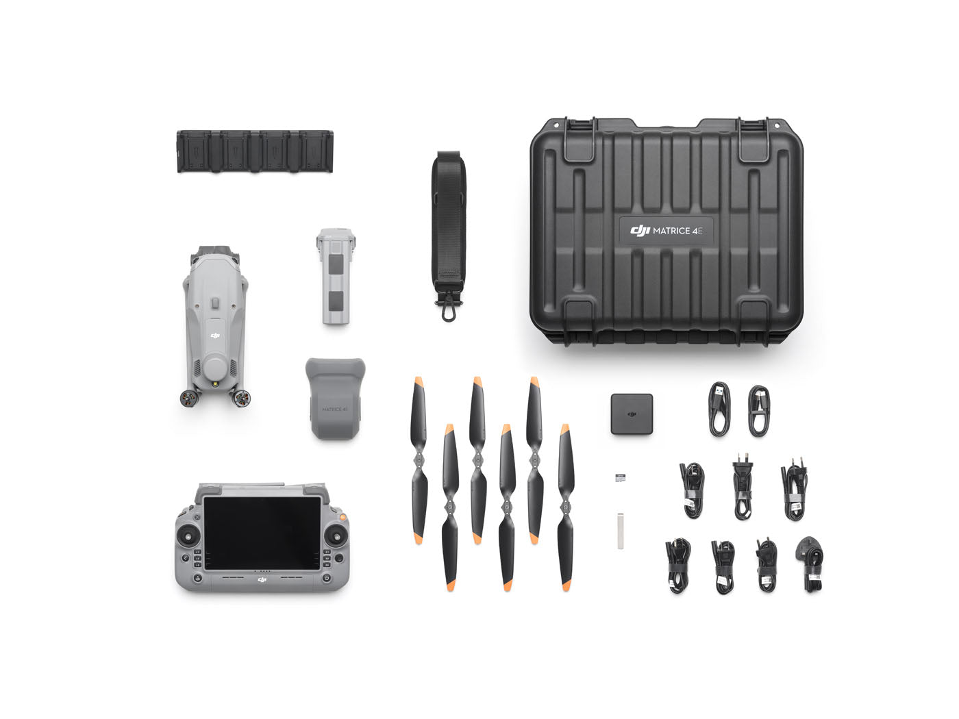
What’s Included
DJI Matrice 4E Aircraft
DJI RC Plus 2 Enterprise Controller
Intelligent Flight Battery
Charging hub and accessories
Propellers and storage case
Key Specifications
Flight Time: Up to 49 minutes
Camera System: 4/3" CMOS mechanical shutter + tele cameras
Mapping Capability: High-speed aerial surveying
Range: Long-range enterprise transmission
Obstacle Sensing: Omnidirectional
Controller: DJI RC Plus 2 Enterprise
Share